


Mount Kilimanjaro National Park
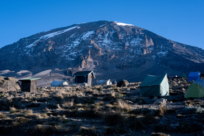
Kilimanjaro National Park covers an area of 652 square miles (1,688 square km) and includes the whole of Mount Kilimanjaro and the surrounding montane forest. Mount Kilimanjaro standing at an impressive 19,341 feet (5,895 metres) is not only Africa’s tallest mountain but also the world's largest freestanding mountain. Kilimanjaro is made up of three volcanic cones - Kibo, Mawenzi and Shira. Mawenzi and Shira are extinct, meanwhile Kibo, the highest peak remains dormant.

More about Mount Kilimanjaro National Park
Kilimanjaro’s summit is often shrouded in clouds and from its lower slopes it is difficult to comprehend the mountain’s actual size but the fact that it takes an average of seven days to climb the mountain should give you an idea of its vastness.
Climbing Kilimanjaro involves no technical climbing or specialized skills, but will require limited amount of scrambling and the use of hands to negotiate some routes.
Mount Kilimanjaro receives approximately 25,000 – 30,000 climbers annually. There are seven official trekking routes up the mountain
Route: Marangu Duration: 5-6 days Distance: 44 miles (72 km)
Marangu is a popular route due to its short duration and low cost. The route approaches the summit from southeast and is considered easy with gentle gradients and scenic sections of rain forest and moorlands. Accommodations are in basic hut shelters which are shared with other climbers. Due to the short duration, the route is poor for acclimatization and has a poor summiting rate.
Route: Machame Duration: 6-7 days Distance: 38 miles (62 km)
Previously Maragu received the highest number of climbers but in recent years Machame has overtaken it in popularity. This route approaches the summit from the south and is considered very scenic. The route is difficult with sections of steep gradient and is very good for acclimatization. Accommodation is tented camps.
Route: Rongai Duration: 6-7 days Distance: 45 miles (73 km)
Rongai requires a long transfer drive to access the trailhead. The route approaches from north and is remote and less frequented. This route lies in the rain shadow of the mountain and receives little precipitation and is recommended in the rainy season (Mar – Jun) when the other routes can be wet and muddy. The route is graded as easy with gentle gradients taking climbers through beautiful alpine desert sections. The route offers good acclimatization and accommodations are tented camps.
Route: Lemosho Duration: 7-8 days Distance: 43 miles (70 km)
The route requires a long road transfer to trailhead. This route approaches the summit from west and is considered remote and less frequented due to its higher cost. The route very scenic and meets up with the Machame Route typically on Day 3. The route is considered difficult but is excellent for acclimatization. Accommodation is tented camps.
Route: Shira Duration: 6-7 days Distance: 35 miles (56 km)
This route is nearly identical to Lemosho except that the trailhead bypasses the lower camp used Lemosho and starts at an elevation of 11,800 feet (3,596 m) and shaves one day off the Lemosho route. As with Lemosho, the route is remote with few climbers and is scenic. Lemosho is recommended over Shira as it provides better acclimatization. Accommodation is tented camps.
Route: Northern Circuit Duration: 9-10 days Distance: 61 miles (98 km)
This is the newest route on Kilimanjaro and currently it receives very few climbers. The route starts from west then takes a very scenic trek across the northern slopes of the mountain before approaching the summit from the east with nearly a 360 degree traverse. Due to the length of time on the mountain, this route is considered the best for acclimatization. Accommodation is tented camps.
Route: Umbwe Duration: 5-6 days Distance: 33 miles (53 km)
One of the least used trail due to the high level of difficulty. This route is the shortest, steepest and offers poor acclimatization due to the short duration. Pre-acclimatization climbs are recommended before attempting Umbwe. The route does offer spectacular ridge views and the summit is approached from the south. Accommodation is tented camps.
For best chances of summiting:
Choose a longer route. The more days on the mountain gives the body more time to acclimatize. The number one reason climbers fail to summit is not lack of fitness but the body’s inability to acclimatize.
Climb during the dry season, between December to February or June to October. Dry weather makes the climbing easier.
Prepare and train well before the climb.
Pack appropriate gear suited for the weather and temperature range and ensure that everything is tested and broken in.
Moments to look forward to
Tanzania Active Honeymoon Safari
TODO - the intro will show on listing pages

Insider-led Tanzania Design & Concierge
Your insider team designs the trip around what you care about, then supports you in-country with private logistics, vetted partners, and concierge help when plans change.
Get StartedPrivate drivers; English-speaking available.
Avoid the crowds in private day tours.
Better stays, better pacing, better reservations.
Insider-only experiences and exclusive local partners.
24/7 in-country support by phone, text, and WhatsApp.
Insider-led Tanzania Design & Concierge
Your insider team designs the trip around what you care about, then supports you in-country with private logistics, vetted partners, and concierge help when plans change.

Real Voices, Real Benefits
We believe travel is more than ticking destinations off a list – it's about discovering new places deeply, feeling connected wherever you go, and knowing you have a trusted team of local experts behind you every step of the way.